
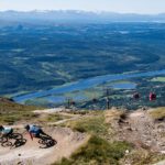


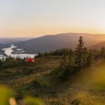

Run up a mountain peak
Take a tour to the top and reward yourself with great views after the climb. Shorten your pace and activate your arms driving you forward for more efficient uphill running. Take a break every once in a while, turn around and look out over the mountain world that lies behind your shoulders. Give yourself a mental highfive when you reach the top – you made it!
Don’t forget your reinforcement garments in your running backpack. You’re protected from the weather and wind in the lower located birch forest, but above the timberline conditions can be different and it is nice to put on a windbreaker as protection against wind and cooler temperatures. Remember that it takes considerably longer to run a kilometre in rising mountain terrain compared to flat asphalt. Give yourself some extra time when you plan your tour, and remember that the most important thing is to enjoy the view!
Around Totthummeln
Elevation: 420 m | Distance: 5,8 km
Around Totthummeln is a favourite amongst many of the villagers. Start at Åre Square or spare your legs some of the height meters and start at Fjällgården. The trail takes you through beautiful mountain birch forest which is lushly green in the summer and crisp in colours when the season goes into autumn. The well-trodden trail takes you above the timberline and makes a detour to the top where you have great views of Åredalen and if you are lucky a really fantastic sunset. To get to the trail that takes you around Totthummeln, run back the same path that took you to the top and continue around clockwise. This section is called the Solstigen and is a nice running trail back to Fjällgården.
Find your way: Take trail 213
Välliste
Stigning: 515 m | Längd: 3,5 km
Välliste is the name of the mountain in Trillevallen and offers a short challenge that is excellent if you decide to run longer with more trails in the area. The trail starts up the hill on the dirt road that goes along the ski lift. The path then turns like a serpentine and it won’t last long until you’re at the top looking out over Sylarna in the west and the Anaris massif in the south.
Find your way: Take trail 241
Västra leden (western trail) to the peak of Åreskutan
Elevation: 1000 m | Distance: 7,6 km
Here you’ll have a real challenge that takes you all the way up to the top of the mountain Åreskutan running along a wider path with a lot of technical sections. From Mörvikshummeln and further up towards to the peak of Åreskutan you run above the timberline and leave the mountain birches behind you. This part of the run you follow the same route as the Vertical K trail enjoying fantastic views all around you. Reward yourself taking the cable car Kabinbanan down and check out the entire route from above on your way down.
Find your way: Take trail 214
Vertical K
Elevation: 1000 m | Distance: 5,6 km
This is the shortest route up Mt. Åreskutan and possibly the most difficult, thanks to the mountain’s altimeters distributed over the shortest possible distance. The record time up Vertical K is 40 minutes, what’s your goal?
Det här är kortaste vägen upp på Åreskutan och eventuellt den allra jobbigaste att springa tack vare att höjdmetrarna uppför skutan fördelas på kortast möjligaste sträcka. Rekordet uppför Vertical K är på 40 minuter, vad siktar du mot?
Find your way: Take trail Vertikal K
Middagsvalen
Elevation: 332 m | Distance: 5,3 km
The route to Middagsvalen is short but eventful. You’ll have time to warm up during the initial kilometre from the trail center in Vallbo, then the climb will soon start to increase. Enjoy the view at the top, you are well worth it. Choose to follow the same route home or run the round tour which is also marked, but where the ground has a wetter character.
Find your way: Take trail 286
Last updated 8 August 2023


