
Weather Phenomena in Åre
The typical Åre weather is rather fickle. And in Åre it can be quite extreme. Does this sound discouraging? It can be sometimes, but it can also be fascinating and awesome! Read on to find out more about ”the lid” and other typical weather phenomena that are common in Åre. And find out what you need to know about winds and cooling effects.
For the latest and most detailed local updates of temperatures, winds and general weather in Åre’s ski area, you should go to Skistar’s website. In Sweden, the national weather service is called SMHI, which is also the most accurate one. There are also other weather services, such as yr.no (Norwegian weather service) and klart.se.
Inversion – the lid is on
The lid is on today – this is a common phrase in Åre during winter. We get out of bed and check the thermometer which displays minus 22. It sounds a bit too cold for skiing and we decide to stay at home. Later, however, we notice that others seem to have had a sunny and amazing day of skiing while we’ve been sitting at home. How is this possible? ”The lid” is an everyday expression for what the meteorologists call inversion. This is a weather phenomenon that occurs when the weather is cool and calm.
Normally, air temperature decreases with a rise in altitude, meaning that the air on the top of the mountain is normally cooler than the air in the valley. When inversion occurs, this relationship is reversed.
The ground cools the lower air layer and because that air contains a lot of humidity, a layer of clouds is formed above. The lower air layer is therefore trapped underneath the clouds and the air temperature above the clouds rises as it is not mixed with the cool air below. Also, the sun does not reach below the clouds and so only heats the air above. The layer of clouds also makes the valley dark while the sun is shining above.
This whole spectacle can cause a difference in temperature of up to 20°C, meaning the thermometer can show minus 20°C in the valley and minus 2°C at the top. So don’t just check the weather apps – check the SkiStar weather and their web cameras to make sure that you don’t miss out on a great day of skiing!
I can See your Halo…
As many of us know, the rainbow is not a bow at all, but a circle. A rainbow occurs when tiny water droplets circulates in the air and catch the sun’s beams as in a prism.
In the same way, tiny crystals of ice can create some awesome light phenomena. One of them often occur in Åre in the winter: the Halo. This phenomenon mostly occur at really high altitudes but sometimes in the winter they also occur closer to the ground.
Simplified: In order for a halo to occur the ice crystals need to be “geometrically perfect” (meaning they need to be made up of straight lines and be hexagonal), they need to vary in form and shape and there needs to be a lot of them in order for a halo to occur.
Pow or Slush
Whether we can expect to enjoy pow-wow the next few days or if they need to order more plaster at the Health Care Center depends on the temperature. For example, when snow falls at minus 15°C it is actually five times ”fluffier” than when snow falls at temperatures just below zero.
At cooler temperatures more air is ”trapped” between the snow crystals which means the snow that falls on the ground is lighter and ”fluffier”. That’s why it’s not obvious how much snow we will actually have when the weather forecast says 1 millimeter of precipitation. At minus 1°C, 1 millimeter equals 1 centimeter of snow. At minus 10°C, 1 millimeter of precipitation equals 3 centimeters of snow, and so on.
Also, at cooler temperatures the air contains less water than at higher temperatures, meaning the snow also contains less water and will be less compact. The wind is also a factor that affect the snow density. The layer of snow will be more compact when it’s windy.
So that’s a short explaination of why we get pow-wow when it snows at minus 15°C and there’s no or little wind but get a completely different snow quality when it’s windy and snows at minus 5°C.
The Wind – a Cooling Companion
Yes, we have a lot of wind in Åre. Most often it’s just a matter of typical mountain weather but sometimes, when skiers or hikers are caught in a blizzard, we may be talking about the treacherous downburst. Most downburst are only noticeable as gusts of wind but sometimes they can be as strong as hurricanes.
There are different types of downbursts and in Sweden these has caused events such as when 100,000 cubic meters of forest fell due to strong and wide-spread downbursts in 2011. It was also the cause of the tragic Anaris accident where eight skiers died in February 1978. The weather had been nice until they were caught in a blizzard caused by downbursts.
”Ordinary winds” might also cause issues. At minus 10°C, moderate winds cause a cooling effect of down to minus 20°C. In short, when it’s windy, the temperature can be much cooler than the number shown on the thermometer. For example, winds of 2 m/s can lower the temperature from minus 10°C to minus 14°C. There are charts that help you keep track of this but the easiest way to check is just to pop your head outside for a bit to decide whether you need an extra pair of undergarments.
Wind – Definitions (Swedish)
Light wind 1-3 m/s: You can barely feel it.
Moderate breeze 4-7 m/s: Wind bursts are quite strong and it is slightly uncomfortable in cool temperatures.
Fresh wind 8-11 m/s: Walking towards the wind is a bit hard. Skiers and hikers who are not accustomed to the mountain should not be out in the terrain.
Moderate gale 14-17 m/s: Weather warnings are issued. It is difficult to go forward and you can only see about 200 meters ahead.
Fresh or strong gale 18-24 m/s: Strong weather warnings are issued. You cannot see anything and you can hardly move forward on a pair of skis even with the wind in your back. Stay off the mountain.
Storm 25-32 m/s: You cannot stand upright. If you have an accident it is hard to survive.
Hurricane 30< m/s: The wind will carry you away. It will be difficult to survive outside if you cannot find shelter.
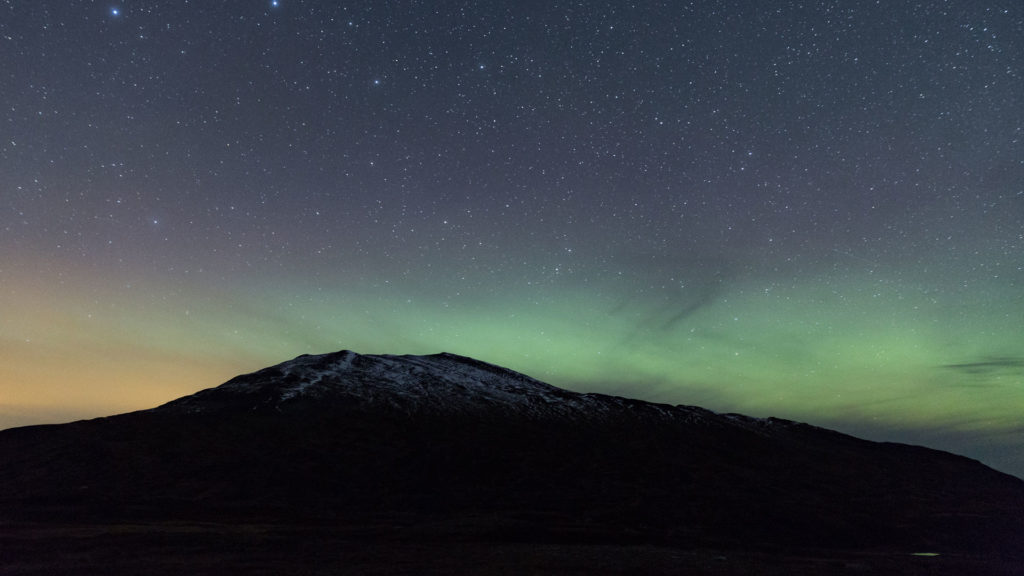
Northern Lights – Aurora Borealis
The Northern Lights is a wonderful weather phenomenon which attract visitors from all over the World to Scandinavia. In Åre it is a fairly common sight during cold nights in the autumn and winter. Want to know where and when to experience it? Read more about Aurora Borealis in Åre here.
Last updated 12 August 2022


Read more
Northern Lights!
The northern lights’ season begin in Åre already in August, b…
Avalanche safety
Before you go off-piste: Make sure to keep yourself and others safe…
Swedish Right of Public Access
Due to the Swedish right of common access you may move freely throu…